Laramie County, WY Floodplain Interactive Map
Navigation Widgets Help
Cheyenne and Laramie County GIS Cooperative
Help Home
Mouse Navigation Tips
While clicking and holding down the left button of your mouse, moving the mouse will cause the map to pan in the direction of the mouse movement.
If your mouse has a wheel, rolling the wheel forward will make the map zoom in. Rolling the wheel backwards will make the map zoom out.
Left click on one of the Navigation Tools to perform the operation of that tool. See explanations of the
Navigation Tools
below.
Top
Touch Screen Navigation Tip
s
To pan the map, touch the screen and then drag your finger around the screen. The map will pan in the same direction as you move your finger.
To zoom the map in, touch the screen with two fingers then move the fingers apart from one another.
To zoom the map out, touch the screen with two fingers spread apart then move the fingers toward one another.
Touch one of the Navigation Tools to perform the operation of that tool. See explanations of the
Navigation Tools
below.
Top
Navigation Tools
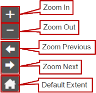
Zoom In
Click on or touch the
Zoom In
icon to zoom the map in a preset amount.
Top
Zoom Out
Click on or touch the
Zoom Out
icon to zoom the map out a preset amount.
Top
Zoom Previous
Clicking on or touching the
Zoom Previous
icon will make the map zoom to the last display extent.
If the
Zoom Previous
icon is grayed out then there is no previous display extent to zoom to.
Top
Zoom Next
Clicking on or touching the
Zoom Next
icon will make the map zoom to the last display extent after using
Zoom Previous
.
If the
Zoom Previous
icon is grayed out then there is no next display extent to zoom to.
Top
Default Extent
Clicking on or touching the
Default Extent
icon will make the map zoom to the original default extent.
Top
© Copyright 2023
Cheyenne and Laramie County GIS Cooperative