As
you begin typing an address or street name in the text box, the
geolocator will start displaying suggestions in a drop down menu. The
closest
matches will be towards the top of the list.
When the desired address appears in the drop down menu, click
on the address to pan/zoom to the location of that address.
Enter the address in standard United States postal code and
abbreviation format with no apartment or unit information.
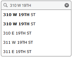
If
there are two identical matches found, like in the image below for 310
W 19th ST, the top address will be the point on the location/building
and the second address will be a point located on the street centerline.
To geolocate a mile marker on an interstate, state highway or
railroad, enter MM plus the number (no space between the MM and the
number) followed by the road or railroad name into the search box. Examples:
Interstate: MM364 I-80 to search for Mile Marker 364 on Interstate 80
State Highways: MM7 STATE
HWY 210 to search for Mile Marker 7 on State Highway 210
Railroads: MM505 UPRR to search for Mile Marker 505 on Union Pacific Railroad
To geolocate coordinates, they must be in WGS84 projection which are the
latitude/longitude coordinates typically provided by a GPS unit. Example:
-104.819, 41.135
The coordinates must be in decimal degree format.
The coordinates must be entered with longitude first followed
by the latitude and separated by a comma.
The longitude must also be proceeded by a minus (-) sign. If
the minus sign is not included, the map will pan/zoom to the other side of the planet and no map will
be displayed.
To convert coordinates from degree/minutes/seconds format to
decimal degrees follow the links provided on the Links
page.