Layer List Help
Cheyenne and Laramie County GIS Cooperative
|
|
Laramie County, WY Sex Offender Verification Map Layer List Help Cheyenne and Laramie County GIS Cooperative |
 to open the
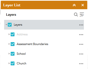
Layer List panel shown here.
to open the
Layer List panel shown here.
 collapses the widget and clicking on the
double down arrow
collapses the widget and clicking on the
double down arrow
 expands the widget.
 closes the widget.
 opens a search text
box. Enter the search text into the search box to search for layer names that contain the text entered. Click
the
Cancel button to end the search.
opens a search text
box. Enter the search text into the search box to search for layer names that contain the text entered. Click
the
Cancel button to end the search.
 opens a drop down box where you can
turn all layers on, turn all layers off,
expand all layers or collapse all layers.
opens a drop down box where you can
turn all layers on, turn all layers off,
expand all layers or collapse all layers.
 to the left of the layer name or turned off by
un-checking the check box.
to the left of the layer name or turned off by
un-checking the check box.
 to the left
of the layer name will expand the layer tree to give access to individual and group layer controls.
to the left
of the layer name will expand the layer tree to give access to individual and group layer controls.
 to the
left of the layer name will collapse the layer tree down to the level of the down arrow.
to the
left of the layer name will collapse the layer tree down to the level of the down arrow.
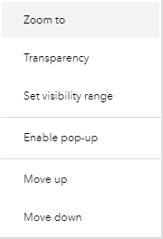
 to the right of the operational layer displays the layer controls.